Iceland in Summer
It isn‘t that easy to describe Iceland
one has to experience Iceland…
but I will try it anyway as follows:
- daily stages and road/track numbers
- short description of tracks and fords
- beauties of nature & sights
- travel time and general experiences
- click to the pictures
We had 21 days on the island. In preparation to plan the trip at home, I was visiting websites, books and different maps. Finally we had to decide what we really wanted to see.
Total distance: 8‘474 km
stage 1:
Arrival at Seyðisfjörður – drive to Eglisstaðir for shopping and fuel.
Ringroad 1 south – 931 – 910 – F909 to the Snæfell lodge – back to 910 over the Hálslóndam to the Lambafell track – track from Laugarvellir to Hvannstóðsfjöll and Àlftadalur (Àsgeirsson p.123f) – F910 – F905 till Möðrudalur Camping
stage 2:
taking F905 back to F910 – F903 oasis „Hvannalindir“ and F902 to Kverkfjöll lodge (Àsgeirsson p.155 resp. p.153) – The ice cave broke down and the track was whipped away by the glacial flood of Jökulsá á Fjöllum, so we had to walk to the ice – overnight stay at Sigurdarskáli.
stage 3:
Via F902 back to F910 – F894 towards Askja. We didn‘t feel like hiking whit all that fog around so back to Drekilodge to get some track and ford information from the ranger. We didn‘t want to drive the „Gæsavatnaleið-Route“ F910 Trölladyngia south alone (Àsgeirsson p.113 f). So our way continued on F88 to another oasis „Herðurbreiðarlinðir“ and along Jökulsá river to ringroad 1- side trip to Námaskarð – overnight stay at Reykjahið Camping Lake Mývatn.
stage 4:
day of hiking and relaxation…..
863 to Krafla – hike to Viti crater and through lava of Leirhnjúkur (some path were closed due to shooting work for the movie „Noah“ with Russell Crowe…) – at the end of the day we relaxed at Mývatn Nature Bath.
stage 5:
Ringroad 1 round Mývatn to Laxárbakki – track via Stöng Heiðmörk crossing Mývatnsheiði to Rauðarfell – 843 north to the bridge – 842 south – Aldeyarfoss – F26 Sprengisandur – F752 till Laugafell (Àsgeirsson p.106 mentioned as F881 by mistake), nice bath and chat in the HotPot – you meet same people again and again in Iceland.
stage 6:
from Laugafell on F752 west down into Vesturdalur (Asgeirsson p.106 – 107) – 752 and ringroad 1 to Akureyri for shopping – 82 north along Eyafjörður – 808 to Àrskógssandur – short visit at Bruggsmiðian, a lovely microbrewery – production of „Kaldi“ beer. They are no allowed to do direct marketing but we were offered the almost whole bunch of beer for degustation. Everything for free!
On this evening we only drove the very few kilometers to Dalvik Camping…..
stage 7:
bad weather…. – continuation on 85 north to Olafsfjörður – tunnel to Siglufjörður – 76 – side trip to Hofsós and to the old turf church at Gröf – on 76 – 75 – Sauðárkrókur – 744 – 745 – along the northern fjords to Blönduós Camping.
stage 8:
today‘s destination was the HotPot at Hveravellir. We didn‘t want to drive all the way on 35 – the Kjölur track – but we knew that there was a big potential of „U-turn“ on the chosen route. From Blönduós on ringroad 1 east to Víðimýri to get fuel – 751 to Mælifell – from there we had two options: side track Gilhagadalur or on F756 Mælifellsdalur. Both tracks come together at Aðalmannsvatn east of Blöndulón. We decided to take F756 because later, we wanted to drive the „old Kjalvegur“. So F756 – F734 south – at the crossroad to Strönukvíslarskáli, further to the south. After approx.6 km you find yourself on the beginning of a former traditional west-east connection: the old Kjalvegur. To get back to F35 one has to cross Svartakvísl and a bit later Blanda river at the „old ford “ (Àsgeirsson p. 92 – 93).
Asgeirsson describes the track from west to east. We made a U-turn at Blanda because there were no tracks going into it… I was so excited that I completely missed to take a picture from Alexander as he walked out in his trunks, with security rope and cross country pole to explore Blanda River…..
All the way back to F756 – over the dam at Blöndulón – F35 to Hveravellir.
stage 9:
35 south – F347 Kerlingarfjöll – hikes to both directions from the parking – back on F347 to F35 south – on a side track into Hvítárnes – overnight stay at Hvítárnesskáli.
First auroras this night!
stage 10:
further south on the side track – F35 – side trip to Gullfoss and Stóri-Geysir – 37 to Miðdalur – F337 north – at Mt. Hlöðufell we decided to take the side track that goes east around the mountain – F338 west – 550 north through Kaldidalur – side trip on F551 to Jaki lodge – short round with our „IceLandi“ on Langjökull‘s glacier ice – back to 550 – 518 to Húsafell Camping.
stage 11:
visit of Hraunfossar and Barnafoss – 519 Reykholt – on 50 ringroad 1 south – 553 to lake Langvatn. We actually planned to drive north on a sidetrack through the valley „Langvatnsdalur“ till 581. This route was not described anywhere and therefore had U-turn potential. Exactly what happened after two thirds of distance along the lake. Maybe our MaxTrax would have helped but the track went on in the same manner, we were just to lazy to take them out. All the way back to ringroad 1 north – 60 north – 54 west Snæfellsnes – crossing the lava of Berserkjahraun on 558 – 54 west – 570 to Snæfellsjökull. We could expect auroras for the night but as Snæfellsjökull is in a nature park, camping is not allowed so we went back to Berserkjahraun where we spent the night – a good decision!
stage 12:
continuation on 54 west around Snæfellsnesjökull – side trip to the stranded sperm whale – some thoughts in silence – 572 to Djupalónssandur – along the footpath to Dritvík and back – 54 east – Borgarnes – ringroad 1 – 54 Hvalfjörður – overnight stay at Hotel Glymur.
stage 13:
on 47 and ringroad 1 to Reykjavík – individual city tour – continuation on ringroad 1 east – 26 an F26 north – F225 – F208 – F224 till Landmannalaugar (Àsgeirsson p.19). A quick bath in the hot creek it shall be a frosty night.
stage 14:
Via F208 south – ringroad 1 – fuel and coffee at Kirkjubærklaustur. We had planned to drive the „Lakicircle“ F206 from Laki, but also wanted to be at Jökulsárlon in the evening. This timetable didn‘t work out. Instead of Laki, we drove back west on the old Mýrdalssandur track to Vík í Mýrdal for a foto shooting of Reynisdrangar. After that we headed east again on ringroad 1 with a side trip to Svínafellsjökull – side trip to Fjallsárlón and got just in time to the glacier lagoon Jökulsárlón – fotoshooting – drive to Höfn Camping had dinner at Pakkhús on the waterfront.
stage 15:
ringroad 1 east – 96 and 955 along the east fjords to Reyðarfjörður – 92 to Eglistaðir for shopping and fuel. We attempt a second drive into the highland to Askja hoping to see the caldera this time. So again 913 – 910 – Hálslóndamm – Lambafell track overnight stay at the Laugarvalladur.
stage 16:
It was a freezing night and still it was cold. We diceded to drive straight on F910 to the Drekilodge. There was snow in the highland and F894 was partially covered with it. Arriving up there we just took another souvenir picture. Back on F88 north to plunge into the nice warm Mývatn Nature Bath.
stage17:
north/east was still on our program:
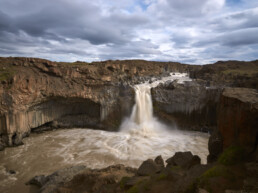
on 862 and 866 to the 3 Waterfalls: Selfoss, Dettifoss and Hafragilsfoss – continuing north – side trip into Vesturdalur – hike to the rocks „Karl og Kerling“ – 862 – 85 east – 861 to Asbyrgi – 85 north till Húsavík.
stage 18:
from Húsavík sidetrack to Höskuldsvatn – via Skörð to 87 south, crossing Hólasandur and Mývatnssandur – 858 and ringroad 1 round the lake with another stopover at the Hot Pots. ringroad 1 towards east – track 864 north to Kópasker – 870 north crossing Melrakkasletta – visit of the Arctic Henge at sunset – Raufarhöfn Camping with another aurora night.
stage 19:
04:30 am – got out of bed and closed the roof tent – f……wind!
at least we had access to electricity on the camping to brew a nice warm coffee. Back on the road – 870 south/east – track east of 870 – 85 – Þórshöfn – 869 Langanes – little walk to the old DC3 near Sauðanes – along the track direction Fontur. It was extremely slow going and the weather was so bad so back to Þórshöfn for breakfast – 85 south – 91 Bakkafjörður – 85 south Vopnafjörður. We wanted to drive on 917 over Hellisheiði pass but heavy rain, fog and wind just pushed us back into the warm Nature Bath…..It was the worst day so far and we decided to stay in the hotel at Reykjahilð.
stage 20:
It was snowing again far down. We had internet, so a quick look on the weather news – better for the evening. Another look on the weather, but this time Spaceweather – oha! a storm was was on the way to earth and strong auroras were expected during the night. As the ferry leaves tomorrow, we had to be at Seyðisfjörður round 5 pm.
Where would the weather be best – where would we have a nice background? Another click on the weather forecast: Mývatn should have a clear night so we decided to stay and pass the day with another „short trip“ and a last visit to the Nature Bath.
We rent a cabin for the night at Dimmuborgir Guesthouse in the first row with plain view to the lake. Then back to the road: ringroad 1 north – visit of the Goðafoss – on 835 direction Grenivik – track F839 direction Hvalvatnsfjörður. We turned around on half way, running out of fuel. Grenivik – 83 south and ringroad 1 back to Mývatn.
stage 21:
after a nice breakfast at the guesthouse we drove with some loops back to Seydisfjörður. Ringroad 1 east – track925 north – 944 and 94 along Héraðssandur over the pass at Geldingafjall to Bakkagerði resp. Borgarfjörður – back on 94 to Eglistaðir and on 93 to Seyðisfjörður. Road was closed for short times – we met the film crew again at work, but as we had time it wasn‘t a problem.
6 pm: like in a sandwich, our Landi was parked in between other Land Rovers, Buschtaxis, Mercedes G cars, SUV‘s and some really cool Oldtimers.
8 pm: MV Norrönna sat sails……..
Tracks
F910:
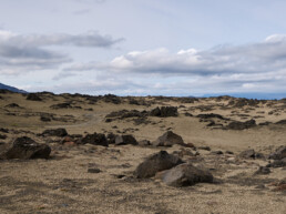
The eastern part of this highland track is the easiest way to Askja. To us it was together with F905 (same area) one of the worst. This washboarding type of track is demanding a lot to the material. Bit higher speed would be more comfortable but it is not possible because of big holes and spiky lava stones.
F903 resp. F902 Kverkfjöll:
F903 is beautiful – no traffic. On both tracks you find sandy slopes in turn with fantastic lava fields. F902 has great colours and only few washboarding.
F88 (Askja-Ringroad):
To us this is one of the most beautiful tracks. Very few washboarding. After the Lindaá ford the track is winding along Jökulsá á Fjöllum.
864 north (Dettifoss):
I don‘t recommend this track – drivable with 4×4 but pure washboarding, holes and stones. To drive along Jökulsá á Fiöllum to Asbyrgi it is much nicer to take the parallel track 862.
F752 from F26 Sprengisandur north:
The northern part of F26 fair to drive. F752 through Sprengisandur till Laugafell was very nice to drive. Sandy slopes, great desert landscape with a view of Hofsjökull. From Laugafell to the west F752 gets pretty rocky. But as there is not much traffic, there is almost no washboarding.
F756 Mælifellsdalur:
No traffic through a beautiful high valley. A little rocky but fairly drivable for off-road cars.
F734 south:
No traffic on this track because aside of Ströngukvíslarskáli (lodge) it goes to no man‘s land. No problem with a offroader.
F35 and F347 Kjölur, Kerlingarfjöll:
It is possible to cross the highland on F35 with a 4×4. Some parts are more rocky, some less – there is a highland bus service on this road. As there is more traffic it has more washboarding.
F347 to Kerlingarfjöll Camping area is easy driving with a SUV
F337 Mjðdalsfjall:
From Miðdalur it goes up a steep hill. Great view. Between Rauðafell and Hlöðufell = fantastic sandy track trough great landscape. The sidetrack is described later
F338 „power line“:
This track is easy driving, not very attractive with some washboarding.
F551 from Kaldidalur to Jaki lodge:
This track is easy driving. From lodge to the glacier it is full of slackly stones – limit for SUV‘s. It is also possible to „plunge“ cars on a glacier…(see fotos)
F225 Landmannaleíð:
This track passes the foot of Mt. Hekla, very nice landscape, no problem for off-road cars, 4×4 passable
F208 Nyðra-Fjallabak:
Beautiful track with some small and mid size fords.
All tracks we have driven on, either at Snæfellsnes or along north- resp. east-fjords, are at least 4×4 drivable and generally in a good shape.
Sidetracks
Lambafjell from Hálslón to F910:
SUV drivable washboard….
Sidetrack Lambafjell – Laugarvalladalur:
Steep and rocky downhill, limit for SUV – no problem for off-road Cars
Hvannstóðsfjöll from Laugarvalladalur:
Only for off-road cars. Steep hill (low gear), the track on the „Fjöll“ is quite unclear – big lava stones – very lonely. When you get onto the track Saudá – Àlftadalshæðir til F910 it get‘s easy driving
Mývatnsheiði Stöng Heiðmörk – 843:
4×4 track passing grazing- and moorland
old Kjalvegur from end of F734 south:
Guess this track is only used by shepherds and adventurers but you can see riding paths. This track is only for off-road cars – the higher the better. The track is extremely washed out, rocky and narrow. The one who want‘s to get to F35 has to cross Svartakvísl as well as Blanda River. More about under „fords“.
Hlöðufell east/Lambahraun from F337:
„Offroad – Onroad“….a lava field of it‘s toughest side. You can hardly see the track pure plates of lava rock and spiky lava stones not always able to avoid. The track is absolutely „slow going“ but very exciting – great landscape. There is a cabin on the west side of Mt.Hlöðufell on F734. One just has to know that, in case of troubles, it is probably the place to walk to because there is no mobile reception in this area!
Langavatn Piste from end of 553 – Langavatnsdalur:
Only for hikers, optimists and „do it yourselfers“….(with offroader).
From the fisher hut on, it goes up the hill to a place with a beautiful view. The last possibility to turn around easily.
From there it goes up and down along the lake – rocky and narrow. Some parts are directly on the lakeshore with deep and loose gravel. We had about two thirds when we got stuck in the gravel and decided to make a U-turn (you can choose between lake or moor).
Mýrdalssandur north of ringroad 1
It is possible to cross Mýrdalssandur on a old track north of the ringroad. I guess it must be the „old track“ through the outwash plain, because there are some bridges that were swept off and not being replaced.
The track is very impressive and easy driving with offroad cars.
Fords
On busy highland tracks like F910 east of Askja, most rivers and creeks are bridged in one ore another way or fords are easy to cross under normal weather conditions by SUV or good 4×4.
Lindaá F88:
According to the ranger at Herðurbreiðarlindir, Lindaá has its highest water level around midnight. A good time to cross the ford is around noon or in early afternoon. Below the ford there is a rope. We were advised to cross the ford within a distance of approx. 1.5 meters from that rope. Downstream there can be quicksand.
We had no problems to cross with a water level of approx. 70 cm. When we crossed the 2nd time about 2 weeks later, there was less water.
Nevertheless we have met people who turned around at the ford and continued their trip on F910.
Grafarlandaá F88:
This ford is no problem for offroad cars. But I mention it because we had to use our winch to help people out of their misery….They have crossed the ford before, drove to Lindaá, made a U-turn and got stuck with their SUV as they crossed the 2nd time. Fortunately they were able to continue their journey after we pulled them out.
Bergvatnskvísl F752:
Àsgeirsson describes on p. 106 that there was a notorious rock where cars got stuck. We did see rocks but not this one. Probably it was pulled out of the way or the ford was moved somehow. We had no problems to cross this ford in the later afternoon with the Land Rover. If one wants to avoid the fords, Laugafell is accessible over F881.
Hnjúkskvísl F752:
According to the ranger at Laugafell, the highest water level is in the evening. We crossed the ford in the morning and there was a quite strong current at approx. 70 cm of water depth but no problem for the Land Rover.
Svartakvísl at the old Kjalvegur:
Àsgeirsson has Svartakvísl east of Blanda on the list of risky fords (p. 10-11 about fords). We wanted to have a look at it as the weather was good but not very warm. After a serious inspection, we decided to drive through. Water level approx. 85 cm, strong current and big rocks. As we made a U-turn at Blanda, we had to pass the ford again about one hour later. And that‘s the way it is with those glacier streams: water level did rise up to 90 cm, the current was of course still very strong, the rocks were not gone and we couldn‘t see the ground anyway. It is not advised to do what we did especially when you travel alone.
Blanda at the old Kjalvegur:
Blanda as well is mentioned by Àsgeirsson on p. 10-11. In another chapter – as described in stage 8, he says: „It can be interesting to drive all the way to the old Blanda ford. Blanda has a very strong current and no one should consider to drive out there“.
After crossing Svartakvísl we believed he would be right.
The fords on F208 south are easy to cross for SUV‘s and offroad cars at good weather conditions.
Since this journey was some time ago, it is quite possible that one or the other of the described fords has been provided with a bridge in the meantime.
Beauties of nature and sights
Kerlingarfjöll:
This area has one of the most outstanding landscape in whole Iceland. You need good hiking shoes. There is no other place to hike through where fire and ice are so close together – wonderful colours surrounded by the „fragrance of sulfur“.
Hvannstóðfjöll:
On this sidetrack you really get the feeling of being alone on this world. Wide landscape, no mobile connections and in case of a brake down, a long hike surrounded with silence.
Mývatn and the Nature Bath:
Mývatn Nature Bath is the „Blue Lagoon“ from the north. Beautiful, clean and friendly.
Mývatn and Krafla belong to one of the most active volcanic areas of the island. Beautiful hiking trails.
Réttir – trailing of the sheep:
There are still horses used to help collecting the sheep in autumn
Jókulsárlon:
Glacier lagoon and its black beach are especially beautiful at sunrise or sunset.
Mýrdalssandur:
This outwash plain seems to be one of the most supervised areas in Iceland. North of it, under the ice of Mýrdalsjökull lies the volcano „Katla“ – one of the 3 most active in the country. Again and again there are glacial outburst floods in this area. The las one in 2011 broke away parts of the ringroad.
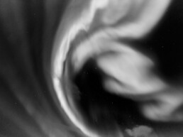
Auroras:
Part of my journal about our last night at Mývatn: “everything was ready, camera, tripod, warm clothing, flashlight. We just had to sit down in the warmth and have a look through the window. In fact it cleared up and around midnight we could see first gray greenish tracks in the sky. I cannot describe what we were able to experience within the next hours – let the pictures talk. Sometime we walked back to our cabin, sat down outside with a beer – just astonished. A truly fulminant finish of our journey“!
There would be so much more to tell…..
Some disappointments:
Hveravellir:
Very touristic. The hot pot was overfilled, the team unmotivated and the showers dirty. Ok, it was end of season in the highland.
The landscape is beautiful.
Landmannalaugar:
How must it be in high season…..
very touristic, no light at night in the sanitary complex – imagine the toilets in the morning…
Beautiful is the hot brook and in the evening when highland busses and day visitors were gone it was ok.
Travel time and other things
travel time:
We were on tour from August 16th till September 5th and thought it was a good time to travel. Less tourists from week to week . Not many mosquitos at Mývatn anymore.
weather:
The weather can change very quickly and it can freeze in the highland at night. Wind is your best friend and never leaves you alone. You have to take warm clothing – real warm clothing. Max. temperature was 18°C.
driving in the highland and on sidetracks:
In settled areas we had almost everywhere mobile connection. There is a quite good coverage in the highland as well. But nevertheless there are big areas where you are on yourself in case of emergency. Rescue service is very good organised and for free but it can take hours until someone can reach you.
We had a storm proved tent, warm sleeping bags and food and water for at least 3 days with us at any time. Our Land Rover has never forsaken us as well as the tires never did!
fuel:
Not many gas stations in the highland – you have to plan well. Along ringroad 1 it is no problem. Usually with a coffebar and a shop. It is only possible to pay with credit card and Pin code or you can buy prepaid cards at the shop (1000, 5000 oder 10‘000 Kronen). It is not possible to pay cash!
Master Card, Visa and Maestro are accepted
navigation, maps, books:
Basic principals for detail planning at home and on tour was:
„Adventure in Iceland“
from Páll Ásgeir Ásgeirsson, Heimur Verlag
Although the book from Àsgeirsson is a 2005 edition, there is no big difference between his descriptions from that time and how it is now. Especially the rating of fords and difficulties are very good.
Iceland maps from Mál og menning Edition 2011 1:300 000 Norðausturland, Norðvesturland, Suðausturland, Suðvesturland and Hálendið
We had no GPS but a magnetic compass (that we gladly never needed)
conclusion:
I can really recommend to travel to Iceland. There is no other country I know, where so many extremes can be seen so close together. Fire, ice, water, sandy deserts, colourful moors and lava fields. A play of colours from nature – up in the sky as well as beneath your feet…. An also there is no other place where you can feel to be so close to the genesis of our earth as in Iceland with its enormous energy that is expressed by bubbling, fizzling, stinking steam and more. Just WOW!